An Introduction to Geography, Geology and Earth Sciences

We moderns are very used to maps, however most of us are familiar with only one or two different kinds of maps: usually a road map, a political map that shows us where counties and states and nations are, and maybe weather maps or topology maps that show us which river is named what and where that mountain range is. The study of geography and earth science involves the study of maps. Not only of cartography (map making) but the translation of information into a visual form. For instance a study of population could be a list of cities and counties, but it's much easier to understand if the data are illustrated on a map with purple for a certain number of people per square km and the empty spaces where no one lives in white and every color in between. This lets us see that London is the most populated place in the British Isles. Obviously, this map above is something entirely different. The study of Geography not only is the study of who lives in what land, but also the study of what kind of trees are there, and what the weather is like, and what minerals lie beneath the earth and how much rainfall is averaged where. Geographers love maps.
Anthropology is the study of the peoples of the earth. Geography touches on these studies like population studies, and general politics. Geology is specifically the study of minerals and earth formations such as deserts and rivers, and botany covers the range of plants over the Earth and hydrology the study of water and meterology the study of weather, but all of these are touched upon in Geography. Even the word, "geography" means "drawing the land." Although there are map pages on this site, these pages show maps, but also scenes showing different climates and how people interacted with the Earth at a time in our distant past. My largest surprise about Anieth was how very similar it was to our own Earth of the not too distant past before the metal machine was everywhere. Yet, first, I want to introduce you to some different kinds of maps. The one above is called a projection, which is a way of taking a three dimensional object like the Earth and turning into a flat picture of the "surface."

These maps of the Liverpool area and Solway Firth are examples of different kinds of relief maps, or maps that show topology or the difference in altitude on the land. The first is a raise relief map that highly exaggerates the elevations of this area. The middle is a map that tries to show the folds and bends of the land with shading. The third is one that shows the elevations and structure of the mountains with shading. The problem with maps is that when you try to show more than one aspect, you get a big jumble of noise. It's often necessary to show the cities so that people know where they are, for most of us don't recognize all places, but maps can get a bit confusing if you try to show too much. Note how the raised relief map also uses color to indicate altitude.
Another kind of relief map is made of lines. These are popular for detailed maps of very confined areas, especially for walkers or day hikes. These maps are incredibly detailed and often have take years to compile

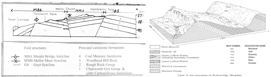
And this is a cross-section map showing an exaggerated altitude scale for a race so that people can see that it was up and down, so to speak. Cross-section maps are very popular with geologists for showing what structure of rock is below.

And this is a cross-section map showing an exaggerated altitude scale for a race so that people can see that it was up and down, so to speak. Cross-section maps are very popular with geologists for showing what structure of rock is below.
And here is another map showing a cartoon of altitude to explain the rain shadow effect of it being very wet on the west of these hills and dry on the east because the wind moves the rain clouds across, they rise over the ridge, get cold, dump rain and then pass on over and have no more moisture for the other side.

Yet these maps show us nothing of what the real landscape looks like. Many people cannot understand maps at all for this reason, that what they see is not what is on the map. The map is information, but not a picture of the landscape itself only a diagram showing some of the information that will tell you different things like the name of a river or that there should be a conical hill over there. Maps require training and a lot of imagination! Yet we find them extremely useful. I'm going to use maps quite a bit to show you different aspects of Anieth, yet I will also show you pictures, I promise!